I first learned of the film City of Fear (1959) from reading a review over at Laura's Miscellaneous Musings and I'm glad she put it on my radar. This little B film has a lot of things going for it; a thrilling plot line, some great camera work, and most of all lots of real world location filming around Los Angeles.
The story is about a killer (Vince Edwards) who breaks out from San Quentin prison with a canister which he believes to contain heroin. However, it's not heroin he is carrying, but a radioactive material that is of great danger to anyone who comes in contact with it and having the potential danger of wiping out an entire city. The convict heads to Los Angeles and it is here that law enforcement attempt to catch up with him before a major population is affected by the dangerous substance in his possession.
Here are some of the many real world filming locations for City of Fear. Click the images to enlarge.
Vine Street looking South toward Yucca Street in Hollywood.
Vine Street looking south toward Yucca Street.
In this first comparison we see the escaped killer, who has taken a driver of a car hostage, moving down Vine Street in Hollywood, just above Yucca Street. We can see a very small portion of The Capital Records Tower which was completed in 1956, just three years prior to City of Fear.
Continuing down Vine Street to Yucca Street.
The corner of Vine Street and Yucca Street.
In the same scene, we get another view of the car from the outside which shows the Vine Manor Hotel. This hotel has since been demolished and replaced by a modern office building.
The Vine Manor Hotel on Vine Street in Hollywood.
The Vine Manor Hotel has been replaced by a modern office building.
In this next scene we see the killer pull into a business which was located at 7827 Santa Monica Boulevard in West Hollywood.
Looking west from 7827 Santa Monica Blvd in West Hollywood.
Looking west from 7827 Santa Monica Blvd in West Hollywood.
7827 Santa Monica Blvd, West Hollywood
7827 Santa Monica Blvd, West Hollywood
In the next couple comparisons below we see a scene that was filmed at the intersection of Fairfax Avenue and Sunset Boulevard. In the first comparison we see two gas stations. Although the buildings have completely changed, there are still gas stations on both corners. And the home behind the gas station on the east side of Fairfax is still there as well.
Looking across Fairfax Ave from the gas station at 7901 Sunset Blvd.
The corner of Fairfax Ave at Sunset Blvd.
The comparison below is also Farifax at Sunset but looking south instead of north. The Thrifty drug store is now a Rite Aid. The building on the opposite corner has been demolished and is now the site of a Bristol Farms grocery store.
Looking toward the southeast corner of Sunset Blvd and Fairfax Ave.
Looking toward the southeast corner of Sunset Blvd and Fairfax Ave.
Thrifty drug store at 7900 Sunset Boulevard.
Rite Aid drug store at 7900 Sunset Boulevard.
Below a cop car drives down Romaine Street in Hollywood, passing what was once the Howard Hughes headquarters located at 7000 Romaine St.
A police car passes the Howard Hughes Headquarters.
Former Howard Hughes Headquarters, 7000 Romaine St, Hollywood.
This next scene is the location where the killer meets up with one of his contacts who works in a shoe store. The store was located on Wilshire Boulevard at the intersection with S. Curson Avenue and right across the street from the La Brea Tar Pits. The shoe store building seen in the film has since been demolished and a new building stands on the site.
Looking down Wilshire Blvd from S. Curson Ave.
Looking down Wilshire Blvd from S. Curson Ave.
One of the few buildings that is still reconizeable is the building with the two chimney's, which is now home to the Craft and Folk Art Museum at 5814 Wilshire Blvd.
Detectives race to the shoe store at Wilshire Blvd and Curson Ave.
The shoe store is gone. Now the site is home to The Counter burger restaurant.
The shoe store at Wilshire and Curson Ave.
The restauarant that stands on the shoe store location.
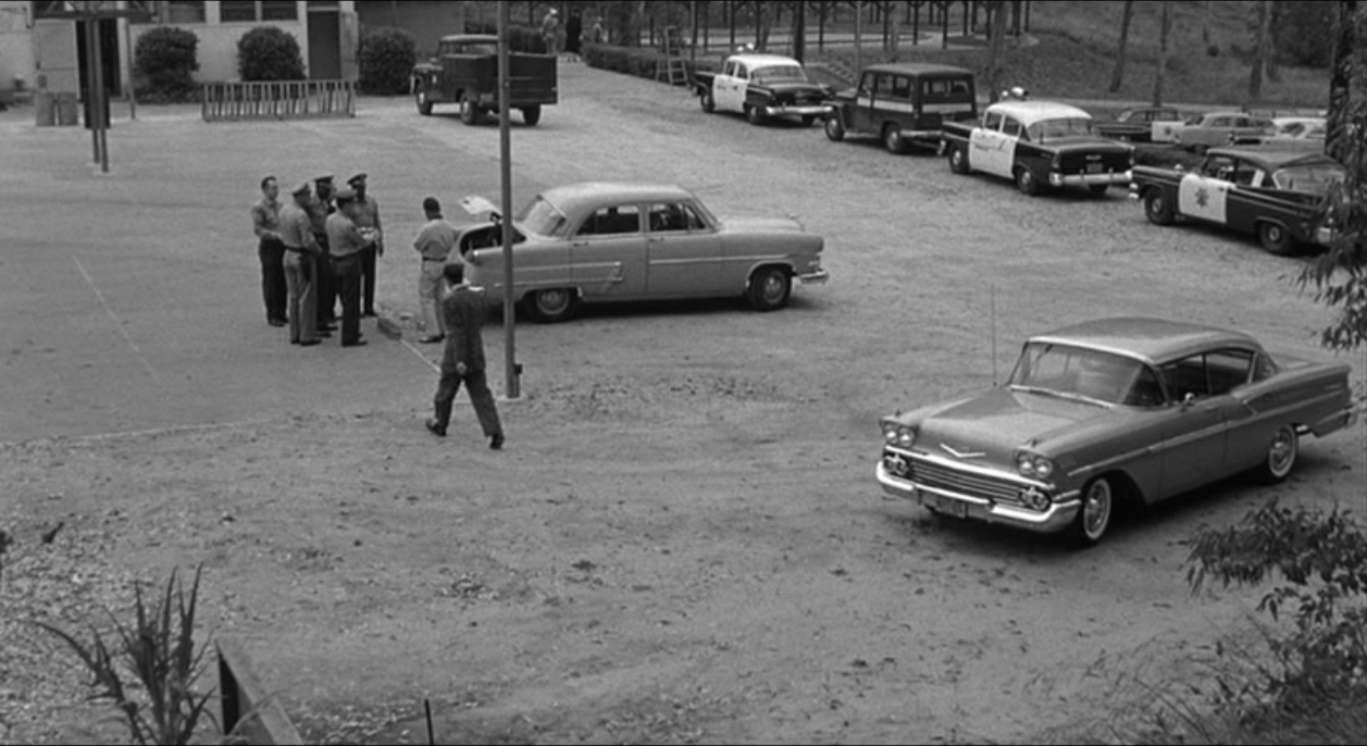
There are several scenes that were filmed in Elysian Park, near Dodger Stadium. Some scenes show police cars driving down the roads that lead to the Police Academy. Much of the action that takes place in Elysian Park was filmed at the location below at the Elysian Therapeutic Recreation Center and surrounding grounds located at 929 Academy Rd., Los Angeles.
Elysian Park Recreation Center, 929 Academy Rd.
929 Academy Road, Elysian Park, Los Angeles
Parking lot at Elysian Park Recreation Center.
Parking lot at Elysian Therapeutic Recreation Center.
Different law enforcement officials are seen coming and going from a brick building with a garage. The building was located at 1012 N. Orange Drive, just a couple blocks north from the Howard Hughes headquarters location.
Looking towards 1001 N. Orange Drive, Hollywood.
Looking towards 1001 N. Orange Drive, Hollywood.
1012 N. Orange Drive, Hollywood.
The brick garage at 1012 N. Orange Dr. has been replaced by this building.
There is a long scene of Vince Edwards driving around Los Angeles. We see Edwards drive south down La Brea Avenue, make a right on Melrose Avenue, then a left on Stanley Avenue. Below are some of the locations we see Edwards pass.
Edwards passes Santa Monica Blvd driving south on La Brea Ave.
Looking down Santa Monica Blvd. from La Brea Ave.
In the scene above Edwards drives pass Santa Monica Boulevard while heading south on La Brea Avenue. The tall building that can be seen in the distance is the Iron Mountain storage facility. This building was previously a Bekins storehouse and before that a building for the Hollywood Storage Co. This 11-story landmark located at 1025 N. Highland Ave. was the tallest structure in Hollywood when erected in 1925.
Another view looking east down Santa Monica Blvd. from La Brea Ave.
Looking east down Santa Monica Blvd. from La Brea Ave.
Edwards turns from La Brea Ave. onto Melrose Ave.
The southeast corner of La Brea Ave. and Melrose Ave.
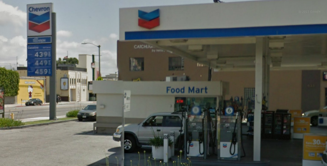
Edwards passes a Standard Station at 7100 Melrose Avenue.
A Chevron station is now located on the site of the Standard Station.
Edwards passes 7116 Melrose Avenue.
The house at 7116 Melrose Ave. is now an Animal Hospital.
Edwards on Melrose Ave. crossing Gardner St.
Looking towards 7473 Melrose Avenue.
Edwards on Melrose Ave. crossing Sierra Bonita Ave.
Looking west down Melrose Ave. from Sierra Bonita Ave.
In the scene below Edwards pulls into a gas station which was located at 7600 Melrose Avenue near the intersection of N. Curson Ave. The gas station has been demolished and a strip mall stands on the site.
Edwards approaches the gas station at 7600 Melrose Ave.
Looking towards 7600 Melrose Ave.
7577 Melrose Ave. can be seen across from the gas station.
Looking towards 7577 Melrose Ave. from the gas station location.
Looking north towards Curson Ave. and Melrose Ave.
Looking north up Curson Ave. from Melrose Ave.
Edwards next makes a left onto Stanley Avenue from Melrose Avenue. Where at the time of the film was a parking lot is now the home of a Starbucks.
Edwards turns onto Stanley Ave. from Melrose Ave.
A Starbucks is now located on the corner of Stanley and Melrose.
Looking from Melrose across Stanley Ave.
One of the homes seen in the background on Stanley Ave.
In the next scene we see a police car cruising a residential neighborhood. I made the assumption that this neighborhood was likely somewhere in Hollywood. I could see that it was on a street with a T intersection, so using Google aerial view, I searched over residential patches in Hollywood looking for T intersections. After eliminating a few intersections I found a home at the corner of N. Orange Grove Avenue and De Longpre Avenue that had windows that matched the house at the forefront of the screenshot. The following two comparison show different views of this location.
Looking west down De Longpre Ave. towards N. Orange Grove Ave.
Looking west down De Longpre Ave. towards N. Orange Grove Ave.
N. Orange Grove Ave. at De Longpre Ave.
The same house at 1400 N. Orange Grove Ave.
The corner of N. Orange Grove Ave. and De Longpre Ave.
The final scenes in the film end with the police catching up with the outlaw on the run. Edwards is seen running around the area near Sunset Boulevard and Gardner Street in Hollywood.
Looking south down Gardner St. across Sunset Blvd.
Looking south down Gardner St. at Sunset Blvd.
A police car turns into an alley near 1512 N. Gardner St.
Looking towards the alley at 1512 Gardner St.
Edwards runs pass 1519 Gardner St.
Looking towards 1519 Gardner St.
Edwards near an alley at 1509 Gardner St.
Looking down the alley near 1509 Gardner St.
Edwards runs into a cafe restaurant located in the alley above Sunset Boulevard near Gardner Street. It's here that the police catch up with Edwards and force him out of the restaurant and into the alley. In the aerial view below, the red circle marks the stairwell where a police officer stands with his gun aimed at Edwards as he comes falling through the restaurant doors and into the alley.
Detectives roll into an alley above Sunset Boulevard.
Bing Bird's Eye view of the alley. The red circle marks the spot of the officer with the gun.
The police move in on Edwards in the alley near Sunset and Gardner.
Looking down the alley near Sunset and Gardner.
Edwards on the ground outside the cafe in the alley.
The cast for City of Fear also includes Lyle Talbot in a small role, John Archer, and Patricia Blair. It was directed by Irving Lerner. The film is available on DVD. I purchased the film as part of the Columbia Pictures Film Noir Classic II DVD set which also comes with the films Human Desire, The Brothers Rico, Nightfall, and Pushover. I strongly recommend this film for lovers of film noir and/or films featuring Los Angeles as a filming location.


